Arizona Hilltop Ruins

thomasinaz

US Veteran
Joined
Aug 29, 2005
Messages
995
Reaction score
1,208
Location
Arizona
Late winter in Arizona is hiking time for me, so I head out to the hills looking for Indian ruins, and burning off some winter fat. I read about these "hill forts" several months ago and have been trying to climb up to as many as I can. These hill forts are a chain of ruins that are in sight of each other, and appear to have been built for defensive purposes. They're built on top of very steep sided hills and cliffs, with only one way to get to each of them. These don't contain any pottery shards or other indications of daily living, like in other more accessible ruins.

This photo is the object of my hike, from about 2/3 of the way up. On the top of the hill you can make out some walls, indicating the ruin.


This is the wall to the right of the entry.


This is inside the ruin, looking back toward the entry and the surrounding countryside.


This is more of the ruin from the back wall area looking toward the entry. To the left of the mountain in the background there's another one of these ruins, which I posted pictures of a couple of years ago. I didn't realize then that these other ruins were here and part of a series of hilltop ruins.


This is from outside the back wall. This wall was the most intact part of the ruin, and it's about 6 feet high on the outside and about 5 feet on the inside.


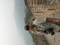
This is me resting against the back wall, happy to have finally made it up here.


This was my second attempt at this ruin. On the first attempt I came at it from the wrong direction and ran into some impassible cliffs. I can't imagine the effort it took to carry all these rocks up here, and build this structure. I can only speculate why they went to all this effort, defensive use and observation of the surrounding country are likely reasons.


Last edited:
Register to hide this ad
"This was my second attempt at this ruin. On the first attempt I came at it from the wrong direction and ran into some impassible cliffs. I can't imagine the effort it took to carry all these rocks up here, and build this structure. I can only speculate why they went to all this effort, defensive use and observation of the surrounding country are likely reasons."

I know what you're thinking. I thought the same thing when visiting the Pyramids of Giza, Great Wall, etc. Incredible!
 

Attachments

  • image.jpg
    image.jpg
    61.2 KB · Views: 120
Last edited:
It's been a while since I was an Archaeology undergrad, but if memory serves these are the hilltop ruins in the Tonto basin N. of Phoenix. There are at least 4 of them. I don't remember them being visibile one to another but suppose they could be. They are thought to have been built in the 14th century by the Salado people, who were one of a number of proto-Puebloan ancestors of modern pueblo tribes, i.e. the Hopi, Zuni etc. Nice photos!
 
I live in central Arizona and have explored many of their ruins over the years. A great deal about their culture is unknown and ever the reason for their disappearance around 1350AD remains a mystery. It is argued that war or famine due to a long term drought was the cause but this is still speculation.
I personally enjoy studying their rock art carvings(petroglyphs sp?) as much as anything else.
Jim


The Hohokam

The Hohokam (/hoʊhoʊˈkɑːm/) were an ancient Native American culture centered on the present-day US state of Arizona. The Hohokam are one of the four major cultures of the American Southwest and Northern Mexico in Southwestern archaeology. Considered part of the Oasisamerica tradition, the Mogollon established significant trading centers such as at Snaketown and are considered to be the builders of the original canal system around the Phoenix metropolitan area, which the Mormon pioneers rebuilt when they settled the Lehi area of Mesa near Red Mountain. Variant spellings in current, official usage include Hobokam, Huhugam and Huhukam.

The Hohokam culture was differentiated from others in the region in the 1930s by archaeologist Harold S. Gladwin, who applied the existing O'odham term for the culture, huhu-kam, meaning "all used up,"[1] to classify the remains he was excavating in the Lower Gila Valley. According to the National Park Service Website, Hohokam is an O'odham word used by archaeologists to identify a group of people who lived in the Sonoran Desert.

According to local oral tradition, the Hohokam may be the ancestors of the historic Pima and Tohono O'odham peoples in Southern Arizona. Recent academic research focused on the Sobaipuri, ancient ancestors of the modern Pima, indicates that Pima groups were present in the region at the end of the Hohokam sequence.[full citation
 
Last edited:
Nice photos.
In the picture following the one of you resting, what is the brown furry looking object / animal to the left of the intact section of wall ?
 
Very interesting. I enjoy finding these spots. Combines two of my favorite non shooting hobbies walking and finding old house places or ruins like this.
 
Enjoyed your pictures. They brought back memories of camping in Homalivi State Park. Lots of Indian artifacts there too, in fact it was allowed to hike the trails and pick up chards of pottery which were everywhere. (you had to put them back too)

I'm still wearing the turquoise/silver watchband I purchased in Tuba City.
Dave
 
I believe the Reptoid aliens are why these people left. But hey, that's just me. :cool:
 
It's been a while since I was an Archaeology undergrad, but if memory serves these are the hilltop ruins in the Tonto basin N. of Phoenix. There are at least 4 of them. I don't remember them being visibile one to another but suppose they could be. They are thought to have been built in the 14th century by the Salado people, who were one of a number of proto-Puebloan ancestors of modern pueblo tribes, i.e. the Hopi, Zuni etc. Nice photos!

This is actually south of the Tonto Basin, but is north of Phoenix. My understanding is the Sinagua ("without water") Indians lived and built in this area. Although there is a ranch about 20 miles east of this with the remains of Indian built canals, so they could be related to the Hohokam, who built the canals in the Phoenix area. (Phoenix named for the town rising from the remains of the old Indian community.)

There are six of these hilltop ruins that I know of in this area, I've been to three. I plan on going to #4 next week, and it's supposed to be the easiest to get to and the least intact ruin. The other two will be harder to get to, they're further off road in more remote country. All the ones I've been to are within sight of each other, so these may be different than the ones you're thinking of.

Thanks for the comments everybody.
 
They are the forerunners to the early warning systems we have today---
open flame at night---smoke by day--they were to signal the inhabitants that danger was coming.
olcop
 
Fascinating stuff to me. Thanks for sharing!
What do you suppose collapsed some of the walls so severely? Are there earthquakes in that region?
 
Last edited:
These may have been the response of sedentary people, living in villages and raising crops, to the attacks of nomadic plains indians, hunters, such as the Sioux, from the Athabascan cultures.
 
This is actually south of the Tonto Basin, but is north of Phoenix. My understanding is the Sinagua ("without water") Indians lived and built in this area. Although there is a ranch about 20 miles east of this with the remains of Indian built canals, so they could be related to the Hohokam, who built the canals in the Phoenix area. (Phoenix named for the town rising from the remains of the old Indian community.)

There are six of these hilltop ruins that I know of in this area, I've been to three. I plan on going to #4 next week, and it's supposed to be the easiest to get to and the least intact ruin. The other two will be harder to get to, they're further off road in more remote country. All the ones I've been to are within sight of each other, so these may be different than the ones you're thinking of.

Thanks for the comments everybody.

Looking them up in the U of A database, thanks!
Once you get north of Phx, there is cultural mixing at nearly every significant site. Lots of movement in the 13th c., much of it northward. When an archaeologist defines a particular site as Hohokam, Sinagua, Salado etc. he's making a generalization about the major features found at a site. Names are misleading too. Sinagua, "without water", is a misnomer given originally by the Spanish to ruins they found that seemed to not have a water source. The most well preserved example of Sinagua habitation is Montezuma Castle (another misnomer) situated on the banks of Beaver Creek, a perennial stream. Whoops!
 

Latest posts

Back
Top