Mt. Evans, the highest peak in Colorado

ancient-one

US Veteran
Joined
Oct 16, 2007
Messages
3,413
Reaction score
8,711
Location
Moore Oklahoma
Especially for you in Colorado. I have been at the summit twice and the last time was a very clear day and it was amazing to look down at the other mountain peaks.
The last time that I went they had a no road maintenance sign at about the 12,500 level. We were in a two wheel drive, stick shift auto and we had a little discussion about proceeding further. I remembered that a lot of the road was nothing but huge flat top boulders so we proceeded and made it with no problem. There are places, that by being cautious, you can turn around.
We were the only ones in miles and the feeling of such vastness and beauty was really overwhelming. About half way to the peak a group of mountain sheep passed in front of the car.
You guys in Colorado should check it out, especially if you have four wheel or all wheel drive vehicles. The road could be messed up but I don't see how because of the mostly boulder base. If I wasn't so old and decrepit I would love to go again.
 
Register to hide this ad
I've done Trail Ridge (Rocky Mtn National Park) quite a few times and it's older one-way dirt road to the top (Fall River Rd.). With Trail Ridge you can continue on down to Grand Lake and beyond. If you haven't done Trail Ridge, I would suggest it for many spectacular views !

Here is a video I snagged from YouTube of the Mt. Evans drive .....

[ame]https://www.youtube.com/watch?v=gvZpP6DC-2A&ab_channel=TheHighwayMan[/ame]
 
I can't remember exactly where......

...in the Rocky Mountains Park, but we were above the tree line and the surface was mostly Tundra. Saw mountain goats all over and it was a great experience. Except my head was pounding so bad I was nauseated. If I do that again it will be like a series of camps like at Everest so I can 'acclimate' over time.:confused:


Update: It WAS Trail Ridge Road, I remembered 'Estes'. Man that was rough being over 12,000 feet.:eek:
 
Last edited:
A good friend of mine used to work that NF, we went up one sunny July day years ago. Still some snow on the side of the road in spots. I believe it was 99 in Denver when we left, 31 at the summit.


Sent from my iPhone using Tapatalk
 
Nice Sunday drive most of the time but not even close to the tallest mountain. In fact we have the highest low elevation of any state at 3,300+ feet. Have 56 mountains over 14,000 feet compared to the state with the next highest count which is Alaska who has on 41. Colorado has over 600 that extend at least 12,000 feet. It was said that if you ironed Colorado out that it would be the biggest state. Don't know if that is true though.
 
Nice Sunday drive most of the time but not even close to the tallest mountain. In fact we have the highest low elevation of any state at 3,300+ feet. Have 56 mountains over 14,000 feet compared to the state with the next highest count which is Alaska who has on 41. Colorado has over 600 that extend at least 12,000 feet. It was said that if you ironed Colorado out that it would be the biggest state. Don't know if that is true though.

Well, it IS close to the tallest mountain in CO. Mount Elbert is the highest mountain in Colorado at over 14,400 feet.

Mount Evans is listed as the highest byway...so the highest you can drive on, and it's listed at over 14,100 feet.

Both pretty tall, especially compared to my home state (PA) with the highest peak being just over 3,000 feet! The highest elevation there is still lower than the lowest elevation in CO!
 
Last edited:
Yes we are quite "lumpy" around here. While Pikes Peak can claim the highest road , that is a maintained road. Many un-maintained roads up on the peaks. Was incorrect in my first post as to number of mountains above 14,000 in Alaska as they only have 14 that reaches that height. Only a total of 24 over 13,000 and 43 over 12, 000'. Our exact count over 12,000" is 673. Alaska looks higher because their base is often lower. The Collegiate peaks range in Colorado home to many of the 14eers has a valley floor of @8,000'on average. I live at 9050' and am not even considered as living "up in the mountains". Elbert is quite a sight and it has a road high up on its side where a gold mining camp once existed. I look out every morning and see it. You will have to come out sometime and let me take you sightseeing.
 
  • Like
Reactions: Rpg
My first elk hunting trip in CO We took a road(trail) that followed a powerline for a ways, then went right between Mt Elbert and Mt. Massive. Two highest in CO. I think they are 10 feet different. this was in 68. Prettiest trip ever. Eventually ended up in Carbondale after starting in Leadville.
 
I been up Pikes Peak several times and I have climbed La Plata.
The 14 K Book says La Plata is an easy one. OK
Have been in a fair amount of CO High Country and ready to go again.
 
Being a Lifetime "flatlander" I don't believe there is a bad view in Colorado. The view from Pikes Peak is spectacular. My boy had to drive the last mile, as I had my head in my wife's lap, I was leaning as far away from the edge as I could get. End of June, snow still around.
XbnPmwB.jpg

Estes Park looking at Rocky Mt NP.
mSbePqf.jpg
The other way, same spot.
wLI0q0f.jpg
Will Rogers shrine looking east.
0JzGmP3.jpg
Heck, even out front of the gift shop, "Cave of the Winds"
rGkcf6S.jpg
Even closed Main Street in Cripple Creek for the "Annual Donkey Race."
sF8A4Ff.jpg

If I could bring my November-April weather there, I'd move a doublewide onto my son's "ranchette" 15 miles east of the Springs. Joe
 
Last edited:
My first elk hunting trip in CO We took a road(trail) that followed a powerline for a ways, then went right between Mt Elbert and Mt. Massive. Two highest in CO. I think they are 10 feet different. this was in 68. Prettiest trip ever. Eventually ended up in Carbondale after starting in Leadville.

You were up Half Moon creek elk hunting then. If you took the dirt road pass named Hagerman through Hell's Gate to get to Carbondale from Leadville you drove right past my old house. . If you took pavement then you must have been over Tennessee Pass, past Camp Hale, and over Battle Mountain to get there from Leadville. We do have a great view.
 
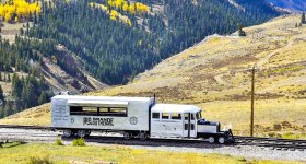
The Goose is Loose!
Here’s Galloping Goose No.5 approaching Osier, CO, elev 9,600 feet.
I dearly the love the Cumbres-Toltec Narrow Gauge Railroad which goes from Chama, NM to Antonito, CO.
Osier is the halfway lunch stop.
You can drive in.
And Galloping Goose No. 5 is home based at Dolores, CO.
 

Attachments

  • B15F41ED-3505-4B75-92D2-372CB4DEF7B5.jpg
    B15F41ED-3505-4B75-92D2-372CB4DEF7B5.jpg
    134.8 KB · Views: 59
Did Trail Ridge years ago on an opening day. It was great not having cars in front of you rubber necking. You are correct...amazing views from the top. Breezy and COLD
 
The Goose is Loose!
Here’s Galloping Goose No.5 approaching Osier, CO, elev 9,600 feet.
I dearly the love the Cumbres-Toltec Narrow Gauge Railroad which goes from Chama, NM to Antonito, CO.
Osier is the halfway lunch stop.
You can drive in.
And Galloping Goose No. 5 is home based at Dolores, CO.

You start talking narrow gauge I hear C. W. McCall singing "Silverton Train".
 
Years ago "C.W.McCall" was the mayor of Ouray. As a side gig he put on a slide show of the local scenery - he held it in the upper floor of the theater. It was 15 projectors onto 5 screens that were side by side. I've never seen anything that came close to it before or since.

Of course, he would sing a song or three after the show if someone twisted his arm at least verbally.
 
Funny thing about C. W, McCall's Wolf Creek Pass hit song about a runaway truck. When he went through the tunnel "and skimmed the top layer of chicken off, like scum off a pond", The tunnel is on the uphill side of the pass if you are going to end up in downtown Pagosa Springs. First guy to have a runaway, uphill.
 
I apologize, I should have said the highest auto road. In the video, which was very interesting ,the road has had a hell of a lot of work and asphalt since my last trip which was around 1983. The road looks more like my first trip when the visitors building was still there. I think that it burned down. There was a coin operated oxygen machine( Dorothy had to have a sniff). They also sold coffee and fresh, hot fried donuts. They were good.
 
And when you get down Wolf Creek headed West, you are a ways from Pagosa, about 10 miles or so.
You want to run down the Pass hauling *** and run right into town?
Head North down Bobcat Pass into Red River, NM.
 
Boys and Girls, today I have a new phrase for you.
It’s Topographic Prominence.
Defined as-
In topography, prominence measures the height of a mountain or hill's summit relative to the lowest contour line encircling it but containing no higher summit within it. It is a measure of the independence of a summit.
For example - here at my house I’m sitting at 5,800 feet above Sea Level.
I can look NE and see the Sandia Crest at 10,800 feet elev.
But since I’m at 5,800, 10,800 - 5,800 = 5,000.
So I can see 5,000 feet of mountain.
It basically means that the lower the elevation you are observing from, the more of a mountain you can see. And the farther away you can see it.
When it’s nice and clear, I can look West and see Mt. Taylor.
Taylor is just over 11,000 and it’s close to 100 miles away.
 
Last edited:
Back
Top