Just how much rain was there?

Register to hide this ad
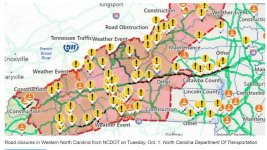
This guy has made an estimate of the amount of rain that fell on the SE US in the period just before Helene struck and during its deluge. Some of the numbers are staggering, and even then there is a strong thought that they are underestimates!:eek:

How Helene and other storms dumped 40 trillion gallons of rain on the South | AP News
Yes, I just read this elsewhere. Incomprehensible.
"...Crews were still trudging through knee-deep muck and debrisin the wake of the deadly category 4 storm that dumped more than 40tn gallons of rain on the southern US after it crashed ashore in Florida on Thursday.

The amount of rainfall is enough to fill Lake Tahoe – with its depth of 1,645ft and surface area of 191 sq miles – or 60m Olympic-sized swimming pools. It could also fill the Dallas Cowboys' 80,000-seat stadium 51,000 times over.

"That's an astronomical amount of precipitation," said Ed Clark, head of the National Oceanic and Atmospheric Administration (Noaa)'s water center in Tuscaloosa, Alabama

Clark said the estimate of 40tn gallons was, if anything, conservative. Also, if that amount of water had fallen in the parched western states, it would have been enough to fill Lake Powell and Lake Mead twice over, he said...
 
Look at the...

Look at this map of closed roads in western NC:

We had some friends vacationing in Maggie Valley in the Smokies. When they set out for home they had no cell phone or internet until they got to Newberry, SC. (about an hour upstate from Columbia) and all the restaurants and stores were cash only and many gas stations couldn't pump gas. They said it was like being on a desert island.

Up until the time of Hugo in 1989 would I EVER have thought that Maggie Valley could be the victim of a hurricane disaster. It killed people in the North and washed out roads in OHIO!:eek::confused:
 

Attachments

  • RoadsClosed.jpg
    RoadsClosed.jpg
    104.2 KB · Views: 43
Last edited:
We got right at ten inches,, over the period of Helene,

i know it was nothing compared to some of Western NC,,
IIRC, Ashville got 30 inches in an HOUR!!

That will flood anything,,
 
Look at this map of closed roads in western NC:

We had some friends vacationing in Maggie Valley in the Smokies. When they set out for home they had no cell phone or internet until they got to Newberry, SC. (about an hour upstate from Columbia) and all the restaurants and stores were cash only and many gas stations couldn't pump gas. They said it was like being on a desert island.

Up until the time of Hugo in 1989 would I EVER have thought that Maggie Valley could be the victim of a hurricane disaster. It killed people in the North and washed out roads in OHIO!:eek::confused:

Heard this morning that the rich folks who everyone hates, have donated the use of their private helicopters in search, relief, recovery efforts.
Franklin Graham whose family is from that area is right in the mix.
 
Been watching videos of the flash flooding on line of both during and after. The devastation is tremendous. Prayers for folks that are suffering with loss of family and homes.
 
Here is an idea of what the flood stages were on the French Broad.And they did exceed the estimates listed

NOAA and USGS river gauges show flooding in WNC river basins. The flood stage begins at 9.5 feet, considered minor flooding. 13 feet is considered moderate flooding, while 18 feet is considered major flooding.

French Broad at Asheville - 13.75 feet as of 7:45 a.m. Predicted to peak at 21 feet at 8 p.m.


French Broad at Fletcher - 20.35 feet as of 8:15 a.m. Predicted to peak at a record-breaking 30.5 feet at 8 p.m.

French Broad River near Marshall - 12.21 feet as of 8 a.m. Predicted to peak at 19 feet at 8 p.m.

Swannanoa River at Biltmore - 17.72 feet as of 8:30 a.m. Predicted to peak at 21 feet at 2 p.m.

French Broad River at Rosman (USGS) - 13.38 feet at 8:30 a.m.

The French Broad is estimated to be one of the oldest rivers, It disects the Appalacian Mountains flowing into the Tennessee River.
 
Back
Top