|
|
 |

12-17-2011, 07:32 PM
|
 |
US Veteran
|


|
|
Join Date: Aug 2005
Location: Arizona
Posts: 995
Likes: 836
Liked 1,209 Times in 289 Posts
|
|
 More Arizona Beauty
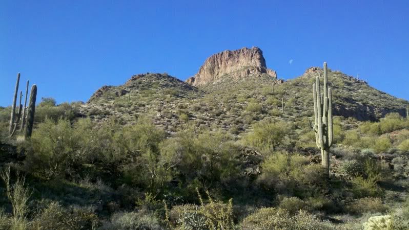
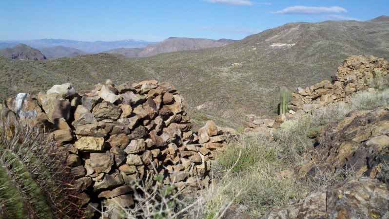
I took a little hike up to the top of some hills, north of Cave Creek, AZ. The first pic is the butte that was goal of my hike. The back side is a little more accessable than the front in this pic.
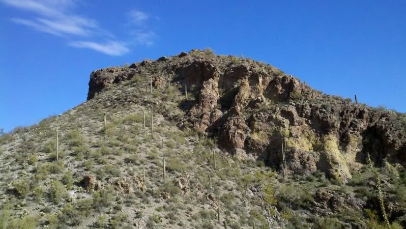
This is the view from the back side of the hill. You can see the remains of an old wall (the four points on the top left). Probably built by Indians, long ago. They're similar to others in the general area, but there aren't any pottery shards or petroglyphs, like in some other ruins I've been to.
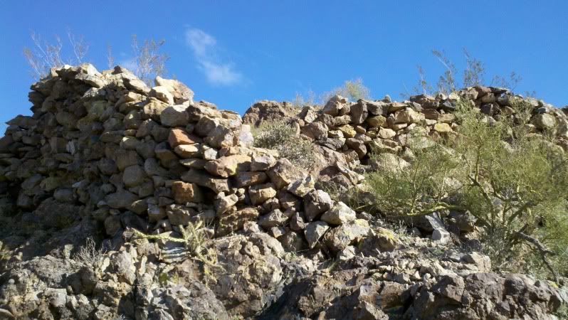
The next couple of pics show the wall from the top of the hill. It took a lot of work for them to build this. The rocks in the walls don't look like the rocks present on top of this hill. I don't know why this would be here, no signs of daily life (no pottery shards or stone chips), and not really big enough for more than a few people. Maybe it was built for protection, as it's very inaccessable with only one way up to it. The only path in is between the wall in the foreground and the wall behind it, in the top pic.
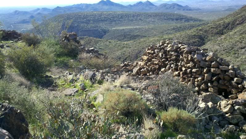
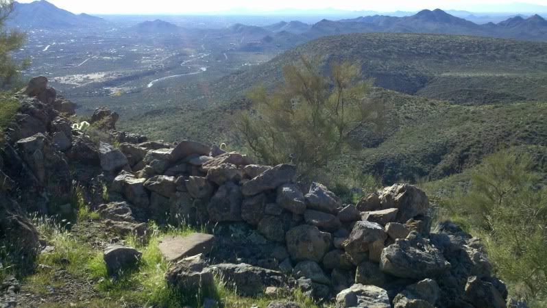
The view from the top with Cave Creek, and the town of the same name, below.
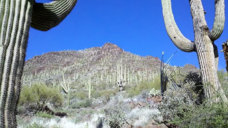
It was a great day, after a couple of rainy days. Almost got lost in the Saguaro forest on the hike back. (Just kidding, this is as close to a forest as we come in this area of Arizona.) 
__________________
Tom
"Panem et Circenses"
Last edited by thomasinaz; 12-17-2011 at 07:40 PM.
|
12-17-2011, 07:58 PM
|
 |
Member
|


|
|
Join Date: Nov 2008
Location: Rhode Island
Posts: 599
Likes: 9
Liked 25 Times in 8 Posts
|
|
I've been to the Cave Creek Recreation Area a couple of time. Is this anywhere near there ?
__________________
regards....roger (no sig)
|
12-17-2011, 08:09 PM
|
|
Member
|
|
|
Join Date: Nov 2006
Location: Mesa, AZ
Posts: 2,823
Likes: 1,256
Liked 634 Times in 358 Posts
|
|
I concur with your assessment that these sorts of ruins are fortifications or redoubts, rather than the perimeter walls of dwelling sites, for several reasons. As you noted, there are typically no pot shards or other artifacts present, suggesting that these sites weren't occupied for any great length of time, they never have any pit house foundations inside the walls, the structures usually have much higher walls than those typically surrounding occupied sites (I believe that the low walls---usually about waist high or even lower --- were designed to keep toddlers in, rather than enemies or critters out) and they are always found at the summit of hard-to-scale/easy to defend buttes and etc.There are many examples of these types of structures ---one in the Cherry Creek area has walls about six feet high, and there's a spectacular example on the Three Bar Wildlife Area near Roosevelt Lake, these both of sufficient size to hold many people. It must have been terribly frightening to get the word that marauders were about and that it was time to round up the women and kids and retreat to the equivalent of a "panic room"...
Enjoy your pix --- keep 'em coming!

|
12-17-2011, 08:52 PM
|
 |
Member
|

|
|
Join Date: Oct 2008
Posts: 826
Likes: 298
Liked 133 Times in 73 Posts
|
|
Nice pics Beautiful, thank you
What area of AZ is that? I have family just outside of Siera Vista
|
12-17-2011, 08:58 PM
|
|
US Veteran
Absent Comrade
|
|
|
Join Date: Nov 2007
Location: Central Indiana
Posts: 1,172
Likes: 463
Liked 130 Times in 64 Posts
|
|
Thanks for posting your photos, Thomas!
Makes me long for the years I lived in Tucson and spent countless weekends hiking the mountains, mining sites and ghost towns between Tucson and Nogales.
Please keep the photos coming!
|
12-17-2011, 09:07 PM
|
|
US Veteran
|
|
|
Join Date: Aug 2005
Location: Arizona
Posts: 995
Likes: 836
Liked 1,209 Times in 289 Posts
|
|
Thank you all for the compliments. Rewster; There are a lot of "Cave Creek" areas around here. Not sure if you mean Cave Creek Park: It's in the top right section of the middle pic, in the group of three pics. It's about 6 or 7 miles, as the buzzard flies, to the south west. There's a Cave Creek Trail Head, which goes into the Cave Creek Trail system, Cave Creek campground, I think there's even a Cave Creek beer. Hard to keep them all straight.  If you were somewhere about 20 miles north of Phoenix, chances are it was nearby....
__________________
Tom
"Panem et Circenses"
Last edited by thomasinaz; 12-17-2011 at 09:10 PM.
|
12-18-2011, 01:20 AM
|
|
US Veteran
Absent Comrade
|
|
|
Join Date: Mar 2005
Location: Texas
Posts: 20,361
Likes: 24,260
Liked 16,170 Times in 7,411 Posts
|
|
The Anasazi and other dwellers in the desert SW did have grim enemies, some apparently the ancestors of what became the Aztecs. Some were cannibals.
Such fortresses were very likely used in earnest. They may have doubled as ceremonial areas.
|
12-18-2011, 10:35 AM
|
 |
Member
|

|
|
Join Date: Nov 2011
Location: Central Texas
Posts: 7,164
Likes: 13,465
Liked 8,505 Times in 2,835 Posts
|
|
Man, we love AZ. As soon as my wife retires we move back there.
Thank you for sharing these pics!
__________________
Jorge
|
12-18-2011, 11:05 AM
|
|
Member
|
|
|
Join Date: Nov 2008
Location: Rhode Island
Posts: 599
Likes: 9
Liked 25 Times in 8 Posts
|
|
The CC Recreation area is north off Rt 74 about 2 miles West of CC. There is a horseback riding stable and a hiking/picnic parking area. From the trailhead at the parking area the trail goes North up the mountain. At top is an old mine that is fenced off. Looks like just a big hole in the ground. From their you can see a network of trails off to the North. It's a great area. You have some really nice photos.
Quote:
Originally Posted by thomasinaz

Thank you all for the compliments. Rewster; There are a lot of "Cave Creek" areas around here. Not sure if you mean Cave Creek Park: It's in the top right section of the middle pic, in the group of three pics. It's about 6 or 7 miles, as the buzzard flies, to the south west. There's a Cave Creek Trail Head, which goes into the Cave Creek Trail system, Cave Creek campground, I think there's even a Cave Creek beer. Hard to keep them all straight. If you were somewhere about 20 miles north of Phoenix, chances are it was nearby.... |
__________________
regards....roger (no sig)
|
12-18-2011, 10:56 PM
|
 |
US Veteran
Absent Comrade
|


|
|
Join Date: Jun 2009
Location: Texas
Posts: 7,579
Likes: 13,500
Liked 6,751 Times in 2,528 Posts
|
|
If those rockpies were places of refuge, like medieval castles, what did they do for water when they were besieged? As an amateur archeologist, I would say they wre ceremonial areas: that's what you say when you can't think of any other explanation.
|
12-19-2011, 12:59 AM
|
|
Member
|
|
|
Join Date: Nov 2006
Location: Mesa, AZ
Posts: 2,823
Likes: 1,256
Liked 634 Times in 358 Posts
|
|
Quote:
Originally Posted by Cyrano
If those rockpies were places of refuge, like medieval castles, what did they do for water when they were besieged? As an amateur archeologist, I would say they wre ceremonial areas: that's what you say when you can't think of any other explanation.
|
The structures typical of Thomas's pix are not identified as "ceremonial" in any way, according to current understanding. There are plenty of examples of "kivas" and similar ceremonial structures spanning cultures and time, but these do not resemble them.
Examined on the ground, in situ, they are plainly redoubts, where going without water, food, fuel, shelter, etc., were the last of their worries. The immediate worries were defending against invading latter day Athabascans (Apaches), who were evidently Mad Max style pillagers and plunderers, preying on hunter/gatherers or farmers. These more sedentary cultures eventually retreated to more defensible positions, such as cliff dwellings, and/or eventually succumbed to Apache depredations...
|
12-19-2011, 05:57 PM
|
 |
US Veteran
|


|
|
Join Date: Nov 2006
Location: Central New Mexico
Posts: 2,675
Likes: 1,180
Liked 1,117 Times in 409 Posts
|
|
Great pics.
__________________
Have guns...will shoot'em.
|
|
 Posting Rules
|
|
|
|
|


 Linear Mode

