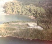
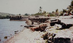
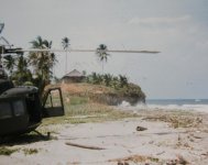
While going through some old photographs I came across this one I took back in 1986 in Panama. The fort is located on the cliffs at the mouth of the Rio Chargres, down stream from the Gatun dam. The dam forms the majority of the Panama canal. The fort changed hands a few times as the naval forces of England and Spain (and pirates) battled it out for control of The New World. Two Caribbean harbors, Portobello and the Bay of Limon were the entry points to get to Panama City on the Pacific side. The cliffs around the fort made it very difficult for ocean going attackers so the Britts put in at the Bay 10 KM south and came through the jungle for their attack on the Spaniards. The wall and ramparts in the right side of the photo were build later to prevent being overrun from the jungle side. When I was in country the old fort was set up like a park so tourist could roam through most of it. I hope my recollection is accurate today, but it's been almost 40 years since I was there.
-
Forum Update: We've upgraded the software to improve security, performance, and the overall experience.
👉 Read why we made the change | Support the Forum
Fort San Lorenzo
- Thread starter Retired W4
- Start date