Had a Bit of an Unintended Adventure on Today's Hike

Is cell service required for gps?

Nope . . . unless you're using Google Maps. Get a different map program that stores the map on your device. I have one called Map Factor Navigator that has a free version or a paid version. Either way you download the map(s) you need and no cell data is required. The only difference between the free and paid version is the free version uses open source maps where the paid version uses TomTom maps. Both work well.
 
As a test this morning on one of my standard 5.7 mile walking routes I used my old inactive LG Ultimate II Android 4.4 (KitKat) and the free version of UnderArmor's Map My Walk tracking app. I call the route the Deerwood Loop. As I approached Deerwood I pulled out the phone unlocked the screen and the app is showing my position on a screen similar to the attached screenshot. I also noticed that the little dot (not pictured) that denoted my current position had an arrow that pointed north acting as a compass. The app will not give you directions, but it will give you a lot of information without a cell or data connection. The same folks offer slightly modified versions of the app called Map My Hike, Run, Bike Ride, and Dog Walk. I actually bought a smartphone because I started riding the bus. The Houston Metro App will fix my location using the phone's GPS and tell me in real time when the next buses will be at my location and a bunch of other things that require mobile data or wi-fi connections.
 

Attachments

  • mapmywalk.JPG
    mapmywalk.JPG
    37.7 KB · Views: 26
Last edited:
tell us how you really feel, :) and how you established the difference there.

The last time I tried eating a mcds burger, was early May about 2 years ago. Id just left from my appt at the local Social security office-having ate nothing sinse waking about 5 hours earlier. I stumbled into the mcds a few blocks away and ordered a bacon cheeseburger, About 4 bites into the meal, I got sick to my stomach seeing different colored dots before my eyes. I then noticed Otis Campbell at another table complaining about pink elephants in the area. I said there aint no pink elephants here, just blue ones.

I walked outside having thrown awAY WHAT i BOUGHT SO THAT NOBODY ELSE COULD GET SICK FROM EATING IT. i LOOKED DOWN, saw a can of ken-l-ration sitting on the ground unopened. It was glowing green and said: made in china. I opened the can, took a whiff and determined it would be much safer to consume. But alas, by then I was more than ready to lose what contents I had in my stomach. I emptied the contents on the ground as there was a starving dog nearby. The dog quickly vacuumed up the food, started glowing green, then disappeared in a flash of bright green light, never to be seen again. Poor poor dog, I tried to help it buit did more harm than good:eek::(
 
Now I gotta research my options a bit.
What am I most likely to have with me at all times on the trail?
I've always been a minimalist. Traveling as light as possible.
Generally all I wear is a pair of boots, a lightweight pair of athletic shorts, my truck key on a string around my neck and a watch.
And off I go.
 
I would save up and buy one with cash, at a major box store with a good return policy. Try it, don't like it or it don't work in the mountains, take it straight back. Nothing lost. But like you said, look at you options on line first.

I'd much rather be broke, than lost?
 
I would save up and buy one with cash, at a major box store with a good return policy. Try it, don't like it or it don't work in the mountains, take it straight back. Nothing lost. But like you said, look at you options on line first.

I'd much rather be broke, than lost?
That's good advice. My digital camera cost $50 less at Walmart than what I could get it for online. They'll take back anything.
 
I've only been "way back in the woods" a few times,I have this natural habit of getting lost anyways....

But I always bring not just a handgun but a rifle along with a large knife and a way to make fire-my thought is if I get stuck I can camp,if I get hungry I can shoot something eventually I'll find my way back out.

I also try and get my bearings somewhat by stopping first thing and figgering out which way is east and west via the sun that way whenever I'm there even if it's right over my head I know it comes up over there and goes down that way....even if I just use a compass that's pretty much all I do with it-see which way is which.

Landmarks too,usually stuff that isn't likely to change,rock cliffs,the shape of a hill/mountain that kind of thing.
 
Snubby:

You gave a list of things that you usually carry with you, but I know that you are famous for your pocket holsters. I presume that you use them yourself, in fact I think I've seen a post of what you usually carry in it. You need to be careful over there on the frontier of the People's Republic of Maryland. One of the PRM border guards might catch you if you wander in the wrong direction!!

By the way, my oldest son and his wife live just outside DC and she works inside the District. First they lived in Tyson's Corner, then Arlington, then Alexandria, and now as far out as Fairfax. Both born and raised in West Virginia. Culture shock, but they love their jobs, and are probably going to be there for awhile. At least they're in Virginia.

Best Regards, Les
 
Last edited:
Snubby:

You gave a list of things that you usually carry with you, but I know that you are famous for your pocket holsters. I presume that you use them yourself, in fact I think I've seen a post of what you usually carry in it. You need to be careful over there on the frontier of the People's Republic of Maryland. One of the PRM border guards might catch you if you wander in the wrong direction!!

Best Regards, Les
I know, it sucks. But some of the best hiking trails are just over the border In Maryland.
I've been doing some research into West Virginia Wildlife Management areas and plan to do some 'sploring there.
You can bet I'll have a pack with some survival stuff a GPS and a compass.
 
Well, I went and ordered a Garmin Fenix GPS watch. It has a "track back" feature that shows you where you've been so you can find your way back.
I figured that I don't always plan my detours and one of the things I always have with me's a watch.
I've recently discovered a few new to me trails that I'm wanting to explore.
It should be here by August 4th.
 
Smart phone is not so smart in WVA mountains .Just took a trip thru to see cousins no service 90% of the trip

You got that right, jmcghee, I live here and when I drive to my camp in the eastern panhandle, about one hour of the drive is no cell service. Guess what? I kinda like it. Especially since I'm still working. "Sorry, boss, but you know how it is, you must have called while I was out of range".

Best Regards, Les
 
Here's a screenshot I took of my phone midway through my walk yesterday. Between the alarm icon and the bars indicating phone signal strength is a rectangle with a slash through it indicating that the 4-G remote data capability is turned off. There is a GPS indicator showing a good fix and it is using maps stored on the phone's memory. The arrow on the dot indicating current position is pointing north. Your problem would be if the hills and woods block getting a good GPS fix.
 

Attachments

  • Screenshot_2016-07-28-06-23-21.jpg
    Screenshot_2016-07-28-06-23-21.jpg
    36.9 KB · Views: 16
Here's a screenshot I took of my phone midway through my walk yesterday. Between the alarm icon and the bars indicating phone signal strength is a rectangle with a slash through it indicating that the 4-G remote data capability is turned off. There is a GPS indicator showing a good fix and it is using maps stored on the phone's memory. The arrow on the dot indicating current position is pointing north. Your problem would be if the hills and woods block getting a good GPS fix.
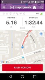
I'm planning on doing lotsa testing on known trails before I even begin to trust it.
Some of the trails do go through hollows with lotsa trees.
I'm hoping I don't end up with just a cool watch.
 
Back
Top