Faulkner
Member
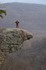
A buddy and I recently hiked out to Hawksbill Crag in the heart of the Arkansas Ozarks. This was one of my bucket list items I've wanted to do for years.
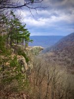
The Hawksbill Crag, also known as Whitaker Point, is located along the northern edge of the Upper Buffalo Wilderness in the Ozark National Forest, just south of the Buffalo National River. It often photographed and recognizable feature in Arkansas, and hikers from around the country trek to the location for the scenic view. The hike to it is a 3.0 mile round trip with a 400 foot elevation drop but offers scenic vistas, huge boulders, and beautiful waterfalls during wet weather. The point where a rock formation juts out from the cliff, known as the crag, overlooks Whitaker Creek and a huge valley stretching as far as you can see.
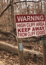
It was a great day for a hike with the temps in the upper 50's, but once out around the cliff face the wind was blowing through the valley at this elevation at about 20 mph making it imperative that you keep a steady foot. My buddy took my picture as I stepped out onto the crag for a uninterrupted look at the view.


The Hawksbill Crag, also known as Whitaker Point, is located along the northern edge of the Upper Buffalo Wilderness in the Ozark National Forest, just south of the Buffalo National River. It often photographed and recognizable feature in Arkansas, and hikers from around the country trek to the location for the scenic view. The hike to it is a 3.0 mile round trip with a 400 foot elevation drop but offers scenic vistas, huge boulders, and beautiful waterfalls during wet weather. The point where a rock formation juts out from the cliff, known as the crag, overlooks Whitaker Creek and a huge valley stretching as far as you can see.
It was a great day for a hike with the temps in the upper 50's, but once out around the cliff face the wind was blowing through the valley at this elevation at about 20 mph making it imperative that you keep a steady foot. My buddy took my picture as I stepped out onto the crag for a uninterrupted look at the view.
Attachments
Last edited:
 ...Ben


") (FJB)
(FJB)