Looks like Helene may be a name to remember

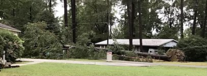
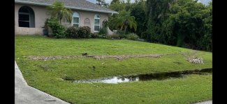
We were spared here in Tucker, GA which is amazing because the flooding, not ten miles away, floated cars away. Before sun rise the Gwinnett County FD made a pass through the neighborhood, checking for hot spots I supposes. I'll get the whole story later.

Our prayers go out to all those not as fortunate as us.
 
Overall, we got pretty lucky in metro Atlanta. The storm was predicted to track right over my location, but it tracked to the east towards Augusta. We have a lot of debris in the neighborhood and lost power for a couple of hours, but I saw no trees down or house damage. Thank you, Lord!
 
I recall time spent in and around the Little Tennessee, Nantahala Rivers, the waterfalls on the Cullasaja. I've seen the spillway opened at Fontana and the overflow off Cheoah Dam. What will the places and in particular the people experience?
With the potential for disaster over the entire region I still find myself wondering what will happen to the Troll Tavern under the bridge on the Chattahoochee in Helen, GA.

The Nantahala is high, but not flooding the restaurant currently.
Nantahala River Live Webcam - Nantahala Outdoor Center
 
Thanks Tcast.
I found a helluva website with a chronological view of the storm. It appears to be dead nuts on with what I experienced in my area as far as the timing of wind speeds, gusts and radar images. Even showed the 70mph gust Kevin in Palm Coast recorded.
Tropical Storm Helene LIVE Tracker, Updates & Forecast | Zoom Earth
I'm saving this one as it appears to be a rabbit hole of historical proportions.
 
Sent this to the kids in upstate Alabama....

Howdy children! We cruised thru the storm last night. Quigley and I went outside during the eye around 3am. We never saw much wind or rain. I believe we were in the direct most path. We lost power for ~2 hours. Interweb machine still down. Thankfully My Deliverer looks over us even in retirement. You kids behave! Much Love ❤️


'
 
Saw this posted on another forum at 10am today.

Sounds most bad.

ncd-L.jpg
 
Guy on TV just said that a hospital in Valdosta is without power. Seems the main supply went out and a tree fell on their backup generator. Not surprised looking at the track on radar last night.

Some authority guy in St Pete (I think) was taking flak from a questioner about evacuations and flooding. The short version of his replies was, "We told you it was coming".
 
Thanks Tcast.
I found a helluva website with a chronological view of the storm. It appears to be dead nuts on with what I experienced in my area as far as the timing of wind speeds, gusts and radar images. Even showed the 70mph gust Kevin in Palm Coast recorded.

I'm saving this one as it appears to be a rabbit hole of historical proportions.

I was using my drone app for winds last night.

image000000%20%283%29-X2.jpg
 
We really lucked out. My wife says we were blessed, I’ll take either. After the water receded, I realized we were only about a foot of vertical water rise before it would have been in our house. There is a very defined line of vegetation debris delineating where the water stopped.

My B-I-L lives in Port Richey on a canal very close to the Gulf and ended up with about 2 feet of water inside. He didn’t move his boat out of the covered mooring on the canal and the rising water probably totaled it by compacting it up into the roof.

My wife has an Uncle out on Treasure Island near St. Pete that ended up with over 6 feet of water in his house and two expensive vehicles that were completely submerged. Only the roof of his pick up truck was still visible.

We don’t know the status of our house up in Tallahassee, but had convinced our youngest daughter to get the heck out of Dodge and come home on Tuesday night before the masses began evacuating.

Now, the insurance nightmare begins for so many. Three weeks ago, we finally got our roof replaced from Ian which hit us two years ago tomorrow. It took a private adjuster, a law firm and a lot of perseverance on our part to keep our insurance company from weaseling out of that one

I’ll have to agree with Mrs. tlawler…we are truly blessed!
 

Attachments

  • IMG_5045.jpg
    IMG_5045.jpg
    66.6 KB · Views: 44
We dodged a bullet. Power went out at 3:30 am. just as the fun started. At 6am. the eye came through and calmed things down for 20 minutes then gusts coming from the other direction. I've heard 56 mph gust at the airport here in Habersham County, GA. Probably going through the eye was a good thing. Anyway we have a 40 ft. tall Pin Oak that sits about 25 feet from the house that had my attention but it's still there. My neighbor had a 6" wide tree across his driveway, my little chainsaw took care of it and I was handsomely rewarded with two cups of hot coffee he cooked up on his Coleman grill. At the time I thought I'd got the better of that deal. Got power back on about 2 hours ago. Surprised, I figured two days at least.
 
Last edited:
I'm beginning to think that a lot of people didn't think this storm would amount to much because of it springing up so quickly and moving as fast as it did. I wonder if people were thinking, 'Oh, it can't be bad. It has not had time to really get going.' Tlawler said his house missed out on flooding by only a foot, and his location is nowhere near the center of the action. Just goes to show how massive Helene became. An interesting animation can be viewed here.

HELENE Graphics Archive: <br> Initial Wind Field and Watch/Warning Graphic

Another clue can be found in the wind history of this storm. The NHC shows that tropical storm force winds moved through the entire state of Florida. No doubt that means the rain bands covered much of the state, likely over ground saturated by the late summer rains FL has had this year.

attachment.php
 

Attachments

  • Helene04.jpg
    Helene04.jpg
    273.4 KB · Views: 201
Lots of water still to flow downhill in the southern Appalachians.
My activities are somewhat limited for a while so with little else to do I keep recalling and wondering about places that I've been with water flowing past.
High Falls State Park off I75 between Macon and Atlanta with the river whose name I cant remember.
Standing Indian Campground on the AT near Franklin with a branch of Kimsey Creek flowing over the Forest Service road.
Reports such as those from tlawler and stories from the Weather Channel of the aftermath are grim.


Towaliga

Towaliga River - Wikipedia
 
Back
Top